The Seaway’s 60th, Part 3: Working at Heights
by: Craig I. Stevenson
Aerial photography captures a River being transformed by the Seaway project, 1955-1960
I
Perspective, in history, is everything.
At ground and water level, the Seaway project commenced and came to completion on an immense scale. It was no small task to move both communities and a River, and to form a completely new and functional waterway.
But to see it simply at that level was to see only what was happening in one specific place, and at a particular time.
For various reasons, the stretch of the River most affected by the Seaway’s construction was of interest to a select few men who saw it from a different perspective, from hundreds of feet in the air.
Stitched together as a visual narrative, the photographs they took of the waterway below leaves a distinct record of a River as it was, as it was transformed, and as it was left as an entirely new waterway, recognizable only in pieces to those who knew it best.
II
We begin with Dwight Church, whose pre-Seaway aerial photographs of the St. Lawrence River constitute an important historical reference point—a view of the River as it once was.
Church, of Canton, New York, operated the “$5-Photo-Co.”, and his work left a rich historical record of mid-20th century life and scenery in the region. A number of his views of the St. Lawrence exist, enough to suggest that the River was both the northern terminus of his flying range and a favoured scene to capture.
Church had an entrepreneurial streak in him, and the celluloid-strip label attached to each “Skyview” of the River suggests that he marketed these photographs to a public interested in obtaining a scenic overview of what was soon to disappear. The following pair of scenes may have been taken after 1954, when the Seaway’s construction became a certainty, or they may have been taken earlier and labelled as such for the period as it was developing.
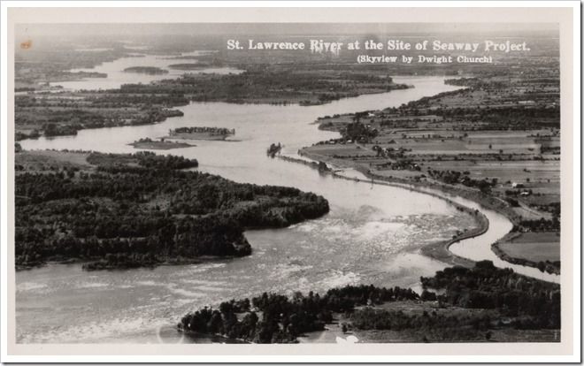
The lower half—with the Long Sault Rapids squeezed between Long Sault Island to the south and Sheek’s Island to the north—captures the raison d’etre of the project. This fall in the River must be overcome to allow larger ships to pass between the Atlantic and the Great Lakes, and it is the strength of this flow that will provide a massive new source of hydro-electric power.
The upper half of the photo is a reminder that not all of the River’s islands were to be found further upstream, and that its course was broken by numerous points and bays. The River’s topography possesses a wrinkled and wooded texture that contrasts sharply against the strips of farmland on the northern shore.
The second Church photograph—taken at a point slightly further to the west, looking downstream—offers a different perspective on the pre-Seaway River.
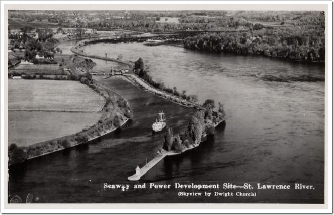
On the left, the protruding jetty and lighthouse mark the upstream entrance to the Long Sault Canal, built to “step” vessels around the rapids. A freighter has just moved up through Lock 21, with its water-control weir visibly spanning the canal. The scene is a reminder that the St Lawrence, for all of its beauty, possessed a utilitarian importance as a maritime route to the continental interior. Along the pre-Seaway River, this maritime influence was felt on a smaller, localized scale, at dozens of points where ships stopped, loaded and unloaded cargoes, and locked through.
Remnants of this scene live on. The lighthouse was relocated to Upper Canada Village and, though non-operational, she still overlooks the River. Lock 21 is a popular diving destination, its weir and sills intact underwater.
III
The most compelling aerial views of the Seaway, under construction, were taken by a photographer who was, at the time, doing something else altogether.
In the 1950s, Ed Clark, from Gananoque, ON, was a young pilot working for Trans-Northern Pipeline, and in 1956 was tasked with conducting a weekly aerial patrol of the Toronto-to-Montreal section of the line. While flying his route, Clark recognized that the river’s transformation below his wings had to be captured.
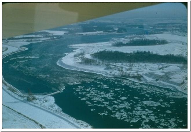
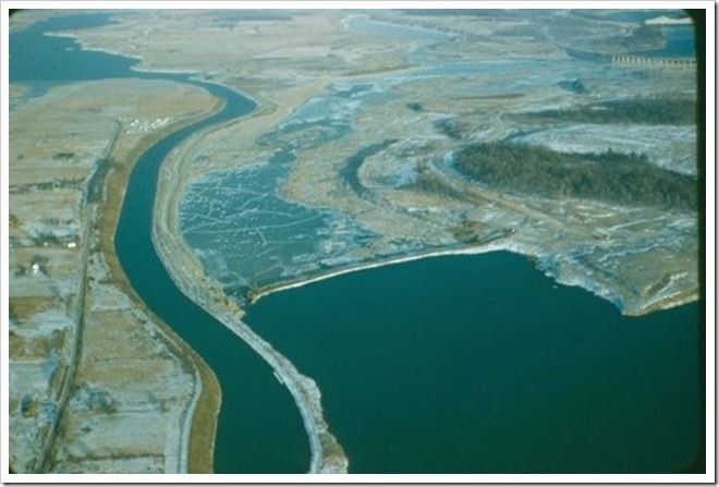
This scene, early in the winter of 1956-1957, is a brilliant view of the River and adjacent landscape, in its early stages of physical transformation. From the left of the photograph, a finger of rubble has started to protrude out into the river’s flow at the point where the rapids begin. This is the temporary cofferdam that, once completed, will choke off the River’s flow over the rapids, so that the construction site can be cleared for the hydro-electric facility.
Barely visible on the extreme right of the photo is the “cut” that has been made through Long Sault Island to divert the flow to the south. Long Sault Island itself has been sheared of much of its forest cover. At its eastern end can be seen the first span of the Long Sault control dam, the spillways of which will help to control the level of the River in the “head pond” section of the River—named Lake St. Lawrence, after the waters are raised.
Pans of ice are still, for the time being, able to flow downstream over the rapids.
IV
As an international project of considerable complexity and magnitude, the Seaway was extensively photographed by the two entities most directly responsible for its construction—the Power Authority of the State of New York (PASNY) and the Hydro-Electric Power Corporation of Ontario (HEPCO).
Carl Malcolm, of Cornwall, Ontario, worked as part of a team of HEPCO photographers who provided detailed views of the project while under construction and in the aftermath of inundation.
At height? Yes, but Malcolm’s photo here is taken from a different perspective.

The angle-iron frame at the bottom of the photograph is a platform, on a hydro-electrical transmission tower, adjacent to the building site of the generation facility that will eventually become the Moses-Saunders Hydro-electrical Dam.
The view looks to the southwest, from the Canadian shoreline, over the construction site and toward the town of Massena, New York. As a moment in time that captures the early stages of power project construction, it is rich in detail. To the left of the photograph, a long line of rounded steel columns, filled with ground, form a cofferdam that separates the building site from the river channel. The River has been diverted upstream by another series of smaller cofferdams, leaving a dried riverbed where preparation of the site can proceed.
In the background—difficult to distinguish, except for their slightly darker shading—are Sheek and Barnhart Islands, and a sliver of the still-operational Cornwall Canal can be seen along the right edge. The excavation site to the right of the cofferdam is where the Canadian terminus of the dam will be located.
V
Some white-water remains, but the pale, exposed shoreline rocks reveal the extent to which the river’s level has been drawn down. To the right, just out of the photograph’s frame, the diversionary cofferdam is nearly complete. The last section of the cofferdam has marshalled a tremendously powerful flow of water. Ground and rock dumped into the gap is being washed away quickly, and the result is clear to see—a plume of silty and muddied water carried far downstream.
VI
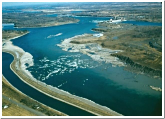
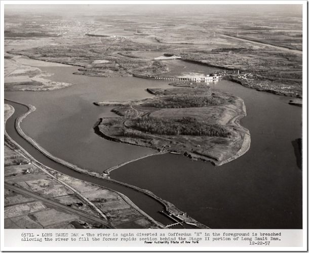
December 1957. Ed Clark photographs the coffer dam at the other end of its life cycle.
Taken a short time after the previous Ed Clark photo, this image from the Power Authority of the State of New York (PASNY) shows how the cofferdam’s breaching has filled the rapids section of the River.
Having served its purpose of diverting the River from the rapids section, the cofferdam is now being opened slowly to refill this channel before full and final inundation the following summer. The cofferdam has been cut on its northern end, near the bank of the shipping canal, and the trickle of water has frozen into shallow sheets along the bed of the former rapids.
The Long Sault Dam, in the top right corner of the photograph, is near completion, and has become a permanent and highly visible feature of the riverscape.
VII
Taken a short time after the previous Ed Clark photo, this image from the Power Authority of the State of New York (PASNY) shows how the cofferdam’s breaching has filled the rapids section of the River.
On the right side of the photograph, the diversionary channel cut through Long Sault Island is readily apparent.
The Long Sault Dam is complete and functional, its spillways releasing a white plume of water downstream. The span below the dam is the bridge used to bring construction materials to the northern section of the dam.
The remainder of the Long Sault Rapids are dried, the waters stopped by another downstream coffer dam stretching between Sheek and Barnhart Islands. The small, dark, lateral line at the top left of the photograph is the nearly-finished Moses-Saunders Dam.
At bottom left, the line of the road—Highway Number 2—still runs east-west along the canal. A new road arcs in from the north, a bulldozed trail that will form the route of the Long Sault Parkway after flooding. These fields will not disappear completely; their highest points will create a new string of causeway-connected islands between the planned towns of Long Sault and Ingleside, Ontario.
The shipping canal will soon be rendered obsolete by the dredged Wiley-Dondero Canal, visible here cutting diagonally across the top right corner of the photograph. The importance of the River as a commercial conduit is, however, too important to allow the transit of ships to be interrupted by the Seaway’s construction. Lock 21, near the soon-to-be-flooded village of Dickinson’s Landing, is still fully operational. The old River will work to its very end.
VIII
The aftermath. This Carl Malcom photograph, taken approximately a year after the River’s level has been raised, focuses on the newly-created Moulinette Island.
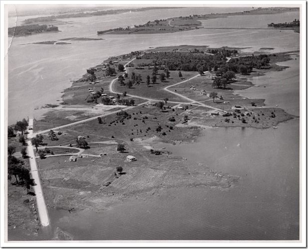
Moulinette Island sits adjacent to the eastern end of the loop of islands that constitute the Long Sault Parkway. It is designated as a cottage island, a site to replace the lost vacation homes on nearby Sheek Island.
Flooding has created an imperfect shoreline, and in short order, people must do what nature had taken millennia to accomplish. Comprised largely of stony pasture, low spots along the shoreline have been dredged back and levelled off to at least create the impression of a distinct separation,between land and water and to lessen the artifice of an island that is really an extension of mainland. One clear sign of its former state cannot be hidden, however, and that is the strip of Highway 2 running vertically along the left edge of the photograph.
Looking above and beyond the point where Highway 2 enters the water, we can see it emerge again on the two small, low islands at the upper left edge of the photograph, and onto Macdonnell Island on the Long Sault Parkway. Together, these snippets of former roadway give a rough impression of where land once met water. To their immediate left, now gone forever, once ran the Long Sault Rapids.
IX
Both sides, now. This is the new River after inundation, the shoreline comprised of water spilled over onto farmland to create a shallow, muddy, northern channel. Ed Clark’s photo captures this transitory moment perfectly, with elements of the old landscape highly visible and standing in contrast to the newly constructed environment.
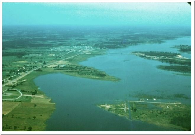
The bottom-right foreground is the former village of Wales, Ontario. The street grid is still visible, as are several building foundations and the north-south road that once ran toward the River. Very faint, the thin and watery line running east-west through the town is the former rail bed of the Grand Trunk Railway/Canadian National Railway.
In the background left, to the east and north of Wales, is the newly constructed town of Long Sault, Ontario, the destination of many homes that have been moved from the villages inundated by the Seaway project.
Directly north of Wales, squeezed between the relocated Highway 2 and the new shoreline, a semicircular roadway marks out a new and very important civic site in the area: the St. Lawrence Valley Union Cemetery.
Fence lines and small, squared fields reveal the area’s recent agricultural past. Time and wind and water will slowly change this view.
IX
The frenzied rush to complete the Seaway project in a remarkably short four-year period is remembered as a period of overwhelming upheaval and change. It could not really be any other way, what with the sheer effort required to transform a powerful waterway and wholly rearrange the lives of the people who lived alongside it.
For the pilots taking these photos, however, height offered the advantage of seeing this change from a more detached perspective, one removed from the noise and tumult below.
The motives for capturing the scenes beneath them varied, but the legacy they left was of singular importance—a visual narrative of a River as it was, and as it became something else altogether, carved to a new shape and purpose.
With thanks to Shirley Clark-Fielding for sharing the photographs from her father, Ed Clark’s collection. The remaining photographs are from the author’s collection.
Craig Irwin Stevenson
Craig Irwin Stevenson grew up in Cornwall, Ontario, and spent an inordinate amount of time on and along the River, at his maternal grandparents’ cottage, on Moulinette Island, the easternmost of seventeen islands created by the Seaway flooding. He is a history teacher at Tagwi Secondary School, in Avonmore, Ontario, and never misses a chance to tell his students that the River they see today, was once a very different place.
Be sure to see two other Stevenson Seaway 60th stories: The Seaway’s 60th and The Seaway’s 60th, Part 2: Another Look at a Lost River.