Carleton Island Royal Shipyard (1778-1788)
by: Dennis McCarthy
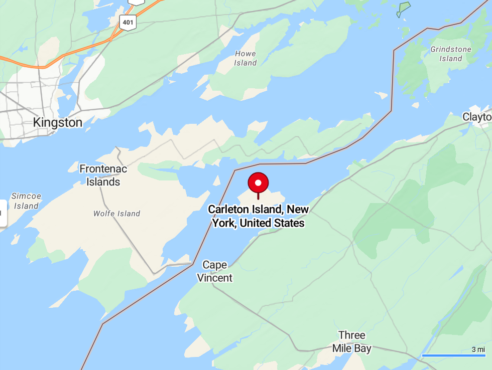
In the summer of 1777, Deer Island (now known as Carleton Island) served as a crucial staging point for Lieutenant Colonel Barry St. Leger's expedition. This was the western prong of the British strategy to seize control of the Hudson River Valley during the American Revolutionary War.
St. Leger's force, a mix of British regulars, Hessian soldiers, Loyalists, and Native American allies, gathered on the island in July 1777. Carleton Island's strategic location at the eastern end of Lake Ontario and the mouth of the St. Lawrence River made it an ideal place to assemble and organize the troops and supplies before proceeding south towards Fort Stanwix (present-day Rome, New York).
From Carleton Island, St. Leger's expedition embarked on its mission to move through the Mohawk Valley and eventually link up with General John Burgoyne's main force advancing from the north. However, St. Leger's advance was ultimately thwarted at the Siege of Fort Stanwix and the Battle of Oriskany, leading to his retreat back to Canada and contributing to the overall failure of the British Saratoga Campaign.
Even though St. Leger's stay on Deer Island was relatively brief, it highlights the island's strategic importance to the British during the Revolutionary War to have a logistical and military post for operations where the St. Lawrence River meets Lake Ontario.
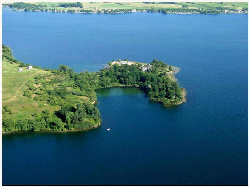
View of North Bay at the head of Carleton Island, the site of the Royal Shipyard 1778-1788 [Photo courtesy SRHF]
IIn August 1778, Governor-General of Canada Frederick Haldimand instructed Lieutenant William Twiss of the Royal Corps of Engineers to select a strategic site at the eastern end of Lake Ontario for a new Royal Dockyard and Naval base. Assisted by John Schank of the Royal Navy, Twiss surveyed potential locations, including the abandoned French fort at Cataraqui (present-day Kingston, Ontario) and a nearby island then known as Deer Island. They ultimately chose Deer Island, which Twiss renamed Carleton Island in honor of Major General Sir Guy Carleton, the governor of Quebec.
The Royal Shipyard on Carleton Island became a vital British military post and naval station. Twiss laid out designs for docks, shipways, a hospital, fortifications (Fort Haldimand), and barracks. Men from the Royal Corps of Engineers oversaw the construction.
Carleton Island occupied a crucial position between the rebellious Thirteen Colonies and the loyal British Colony of Canada. It served as a major staging area for military actions, a transshipment point for supplies to western posts, and the headquarters for naval operations on Lake Ontario and the Upper St. Lawrence River.

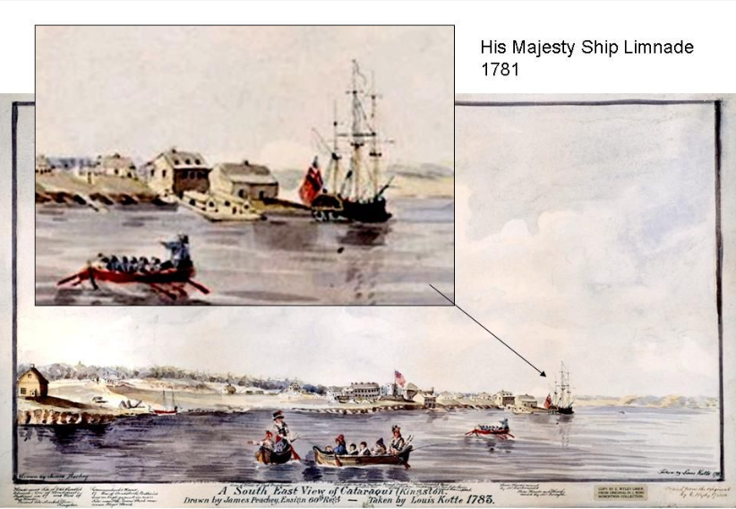
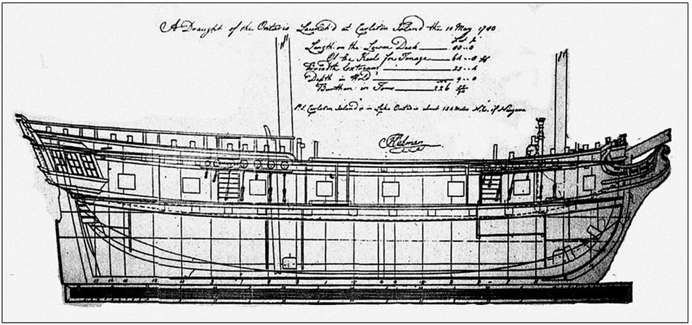
L: Admiralty plans for the HMS Ontario, 1780; R: contemporary painting including the HMS Limnade, 1781. [Photo courtesy SRHF]
The shipyard built and maintained the British fleet on Lake Ontario. The most well known ship was the Ontario, a 22-gun and “snow" rigged. She was the largest British warship on the Great Lakes at the time (80 feet in length). She was constructed there and launched in 1780. Ontario sank in a storm on Lake Ontario in October 1780, taking all 129 people on board with her. To replace the Ontario, the shipyard built the Limnade in 1781. This 226-ton, 80-foot, ship-rigged vessel was armed with sixteen 6-pounder guns.
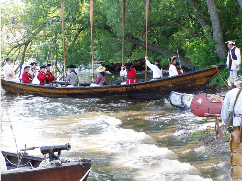
Besides constructing large warships and taking care of the Lake Ontario fleet, the shipyard also built and maintained smaller boats. They constructed flat-bottomed boats called scows, military boats known as gunboats, and bateau (a type of light, flat-bottomed boat). They also built six-oared boats.
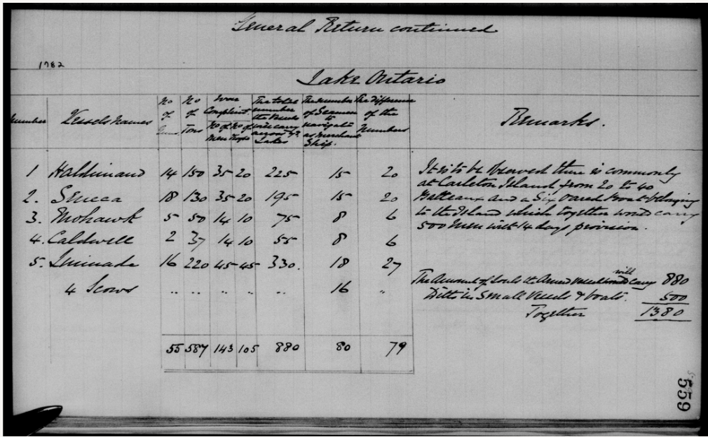
In 1782, a report on the boats on Lake Ontario mentioned that Carleton Island usually had between 20 and 40 bateau and six-oared boats. These boats combined could transport 500 men along with enough food for 14 days.
Construction of Fort Haldimand, a key defensive structure, began in 1778 to protect the island's shipyard and naval station. By 1782, the western end of the island was fully occupied. Records indicating that over a thousand merchants, camp followers, soldiers, sailors, Indigenous people, and displaced Loyalists resided there at times. Carleton Island also served as a refuge for Loyalists fleeing persecution from the American rebels.
After the Treaty of Paris that ended the American Revolution in 1783, the British army began to reduce its activities on Carleton Island. Although the island was technically ceded to the United States by the Jay Treaty in 1796, Britain maintained control until the War of 1812. The strategic need for a new naval and military position became apparent. In 1785, the transshipment point for government stores was relocated from Carleton Island to Cataraqui, which was then renamed Kingston. The merchants who had handled transshipment on Carleton Island also moved their operations to Kingston.
In 1788, the Royal Naval Dockyard was officially relocated from Carleton Island to Point Frederick in Kingston, Ontario. This new location became the sole Royal Navy base on Lake Ontario, playing a crucial role in countering the American naval base at Sackets Harbor, New York during the War of 1812.
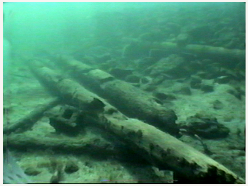
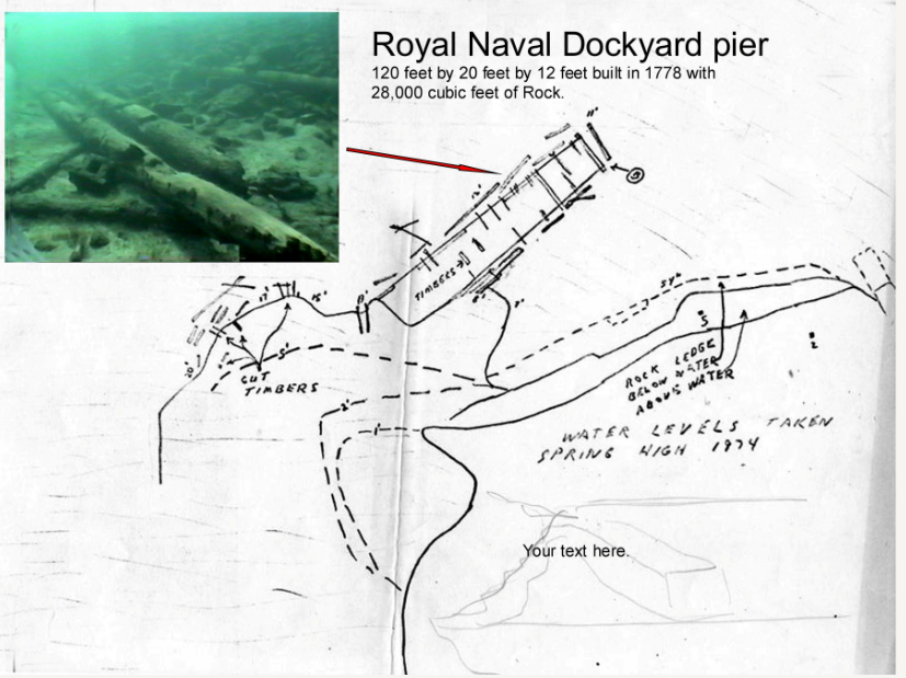
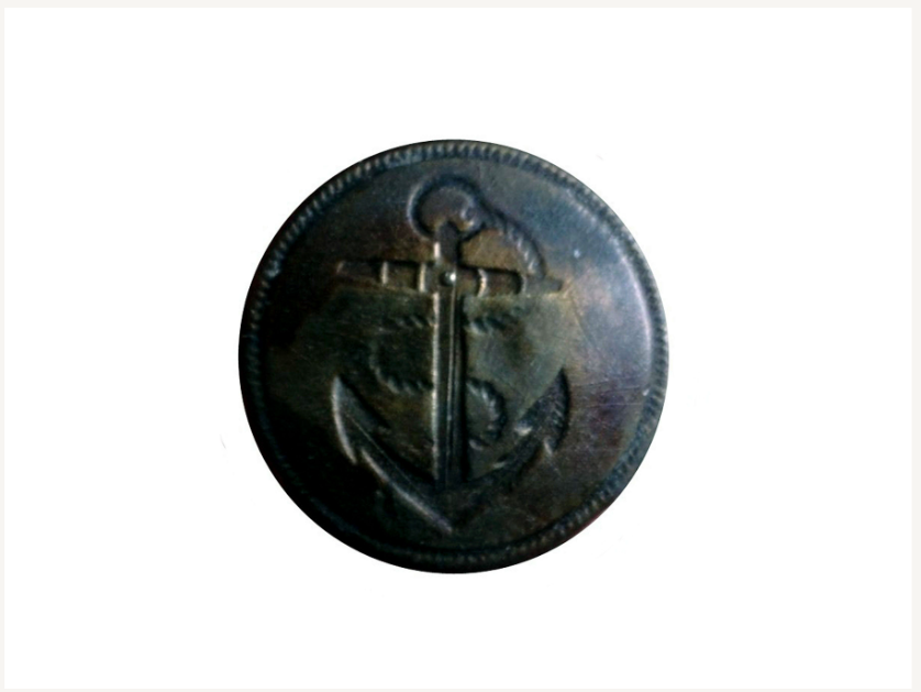
L: Underwater photo of the remains of the Royal Naval Dockyard pier in North Bay, Carleton Island; M: Drawing of the Royal Naval Dockyard Pier; R: British Provincial Marine Officer's button founding during 1974 by the New York State Divers Association, NYSDA Survey of North Bay. [Photos courtesy SRHF]
Today, quiet North and South Bays at the head of Carleton Island aren't politically important to the U.S. or Canada. The only things left to remind us of their past are hidden underwater in North Bay or buried in the overgrown land above. In 1788, when the shipyard here was moved to Kingston, Canada, everything valuable, including tools and whole buildings, were taken with it. Now, only random old items occasionally found remind us that this spot was once the most important meeting point of the St. Lawrence River and Lake Ontario.
Types of vessels built at Carleton Island.
• Snow-rigged: A two-masted vessel, similar to a brig, but with a trysail mast stepped immediately abaft the mainmast. This trysail mast carried a gaff sail (a fore-and-aft sail) that could be set without interfering with the square sails on the mainmast. Snows were known for their speed and maneuverability.
• Ship-rigged: The most common and powerful rig for larger vessels in 1780. A ship-rigged vessel had three (or more) masts, all of which carried primarily square sails. The masts were typically a foremast, mainmast, and mizzenmast. This rig provided significant sail area, making them suitable for long ocean voyages, heavy cargo, and naval warships (like ships of the line and frigates).
• Scow: A flat-bottomed boat, typically broad and shallow in draft, designed for carrying heavy loads in shallow waters. In 1780, scows would have been used extensively for transporting goods on rivers, lakes, and along coastlines where deeper-draft vessels couldn't go. They were often propelled by oars, poles, or a simple sail.
• Gunboat: A small, armed vessel primarily designed to carry one or more cannon for military purposes, particularly in shallow waters or for coastal defense. In 1780, gunboats would have been used for protecting harbors, or supporting amphibious operations. They were often propelled by oars or a simple sail and were vital for defending strategic waterways.
• Six-oared Boat: A small, open boat propelled by six oars, usually with three rowers on each side. These boats were highly versatile and common in 1780 for a variety of purposes. They could be used as tenders for larger ships, for short-distance transport of personnel or light cargo, as fishing boats, or for naval duties like scouting or carrying dispatches in good weather. Their size allowed for relatively swift movement by oar.
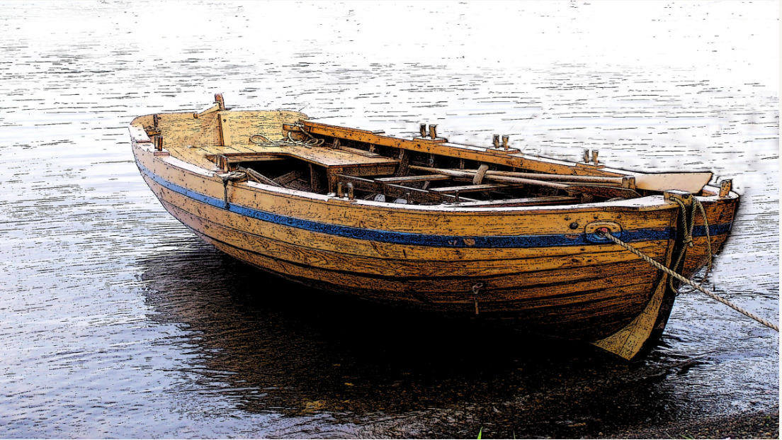
• Bateau: A light, flat-bottomed boat, tapering to a point at both ends. It was commonly used in North America, particularly on rivers and lakes, for transportation of goods and people. In 1780, bateaux were essential for explorers, traders, and military forces operating in the interior, valued for their shallow draft and ability to be easily portaged around rapids. They were typically propelled by paddles or poles.
By Dennis McCarthy
Dennis R. McCarthy lives in Cape Vincent, NY, along with his wife Kathi. He is a graduate of the Rochester Institute of Technology, with a degree in Electrical Engineering. Dennis has been diving since 1971. He co-founded the St Lawrence Historical Foundation Inc. in 1994 and currently serves as one of its directors. His memberships include the Nautical Archeological Society (where he holds an NAS 2 certification) and the Ordnance Society of Great Britain. He is a past president of the Clayton Diving Club. Both Dennis and Kathi serve on the board of the Cape Vincent Historical Museum and are past members of the Advisory Council for the Proposed NOAA Lake Ontario Sanctuary.
See past articles by Dennis McCarthy here and here.
For more history about Fort Haldimand and Carleton Island see the website: https://www.forthaldimand.com/; and the Thousand Islands Land Trust Fort Haldimand Preserve.
Video of the HMS Ontario sunk in 1780 in lake Ontario. The ship was found by Dan Scoville and Jim Kennard in June 2008.